Share My name is Josh Schlossberg, I’m a Nederland resident renting a home in Big Springs which I am considering purchasing.
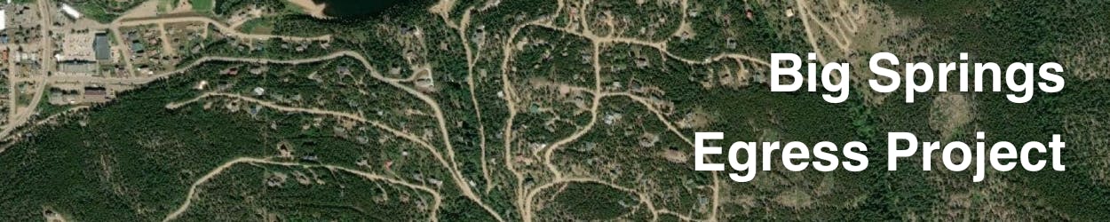
I and many other neighbors I’ve spoken to do not understand why the egress route that would work best for safely evacuating us—across the dam over Barker Reservoir to connect with 119 to head down to Boulder—isn’t even on the list.
Clearly, the Barker Dam route is by far the shortest, quickest, and easiest way to get us neighbors to safety in the event of a wildfire, and the fact that it’s not even on the list is troubling and makes it hard for some of us to believe in the current decision-making process.
(Sadly, until I personally spoke to them, I found many of my neighbors weren’t even aware of the current proposals or public process, and many probably still aren’t aware. To remedy this, the Town should do a better job communicating with us neighbors, interface more with media, and engage more often on social media platforms—while addressing the ongoing censorship of this and related discussions by certain admins and gatekeepers.)
Instead, two of the proposals (Ridgeline and Doe Trail) would aggressively cut through mature and old-growth forest (yes, old growth by all definitions) and sensitive riparian areas through close to a mile of Boulder County Open Space and National Forest. Due to the expense and ecological harm, these proposals should immediately be removed from consideration.
The third route (also through National Forest) is redundant because it is less than ¼ mile from the two other existing egress routes down Big Springs towards town and up Peakview to Highway 72. A third route in the same location only to lead residents deeper into the forest—almost certainly where any wildfire would be coming from—would at best have next to no value and at worst be a death trap, and should also be removed from consideration.
Due to the fact that three bad proposals are the only ones currently on the table—with the only sensible proposal left out entirely—makes many of us worry that the current goal of the project isn’t so much getting us residents to safety in the event of a wildfire, but spending the $600,000 grant funding from Rep. Neguse’s office (and whatever other taxpayer funding is available) and then checking a box to say it’s “done” to avoid further responsibility.
https://neguse.house.gov/services/community-project-funding-selections
Another factor to consider is that 84% of wildfires are human caused, with 94.9% of those ignited within 800 meters of a road, and 60.7% within 200 meters.
https://phys.org/news/2017-02-humans-percent-wildfires-season-decades.html
https://www.pacificbio.org/publications/wildfire_studies/Roads_And_Wildfires_2007.pdf
Building yet another road through our already heavily-roaded forests means spending taxpayer money to create an additional vector for human-caused wildfires to threaten our homes and lives.
If this process is to retain credibility as to its stated goal and to reach consensus among us neighbors who this route is ostensibly for—getting Big Springs residents to safety during a wildfire—the Barker Dam route needs to be the sole proposal.
(While I personally support the Barker Dam egress, it’s also important to acknowledge that some neighbors I’ve spoken to don’t believe an egress road is necessary at all. Early warning systems means quick and safe evacuation is already feasible for residents, as fires rarely come out of nowhere. The reality of Big Springs is that many of us moved here specifically because there aren’t more roads bringing in traffic, construction, and increased fire danger to our homes, and ALL of all us chose to live here knowing the risks).
on Facebook
Share My name is Josh Schlossberg, I’m a Nederland resident renting a home in Big Springs which I am considering purchasing.
I and many other neighbors I’ve spoken to do not understand why the egress route that would work best for safely evacuating us—across the dam over Barker Reservoir to connect with 119 to head down to Boulder—isn’t even on the list.
Clearly, the Barker Dam route is by far the shortest, quickest, and easiest way to get us neighbors to safety in the event of a wildfire, and the fact that it’s not even on the list is troubling and makes it hard for some of us to believe in the current decision-making process.
(Sadly, until I personally spoke to them, I found many of my neighbors weren’t even aware of the current proposals or public process, and many probably still aren’t aware. To remedy this, the Town should do a better job communicating with us neighbors, interface more with media, and engage more often on social media platforms—while addressing the ongoing censorship of this and related discussions by certain admins and gatekeepers.)
Instead, two of the proposals (Ridgeline and Doe Trail) would aggressively cut through mature and old-growth forest (yes, old growth by all definitions) and sensitive riparian areas through close to a mile of Boulder County Open Space and National Forest. Due to the expense and ecological harm, these proposals should immediately be removed from consideration.
The third route (also through National Forest) is redundant because it is less than ¼ mile from the two other existing egress routes down Big Springs towards town and up Peakview to Highway 72. A third route in the same location only to lead residents deeper into the forest—almost certainly where any wildfire would be coming from—would at best have next to no value and at worst be a death trap, and should also be removed from consideration.
Due to the fact that three bad proposals are the only ones currently on the table—with the only sensible proposal left out entirely—makes many of us worry that the current goal of the project isn’t so much getting us residents to safety in the event of a wildfire, but spending the $600,000 grant funding from Rep. Neguse’s office (and whatever other taxpayer funding is available) and then checking a box to say it’s “done” to avoid further responsibility.
https://neguse.house.gov/services/community-project-funding-selections
Another factor to consider is that 84% of wildfires are human caused, with 94.9% of those ignited within 800 meters of a road, and 60.7% within 200 meters.
https://phys.org/news/2017-02-humans-percent-wildfires-season-decades.html
https://www.pacificbio.org/publications/wildfire_studies/Roads_And_Wildfires_2007.pdf
Building yet another road through our already heavily-roaded forests means spending taxpayer money to create an additional vector for human-caused wildfires to threaten our homes and lives.
If this process is to retain credibility as to its stated goal and to reach consensus among us neighbors who this route is ostensibly for—getting Big Springs residents to safety during a wildfire—the Barker Dam route needs to be the sole proposal.
(While I personally support the Barker Dam egress, it’s also important to acknowledge that some neighbors I’ve spoken to don’t believe an egress road is necessary at all. Early warning systems means quick and safe evacuation is already feasible for residents, as fires rarely come out of nowhere. The reality of Big Springs is that many of us moved here specifically because there aren’t more roads bringing in traffic, construction, and increased fire danger to our homes, and ALL of all us chose to live here knowing the risks).
on X (formerly Twitter)
Share My name is Josh Schlossberg, I’m a Nederland resident renting a home in Big Springs which I am considering purchasing.
I and many other neighbors I’ve spoken to do not understand why the egress route that would work best for safely evacuating us—across the dam over Barker Reservoir to connect with 119 to head down to Boulder—isn’t even on the list.
Clearly, the Barker Dam route is by far the shortest, quickest, and easiest way to get us neighbors to safety in the event of a wildfire, and the fact that it’s not even on the list is troubling and makes it hard for some of us to believe in the current decision-making process.
(Sadly, until I personally spoke to them, I found many of my neighbors weren’t even aware of the current proposals or public process, and many probably still aren’t aware. To remedy this, the Town should do a better job communicating with us neighbors, interface more with media, and engage more often on social media platforms—while addressing the ongoing censorship of this and related discussions by certain admins and gatekeepers.)
Instead, two of the proposals (Ridgeline and Doe Trail) would aggressively cut through mature and old-growth forest (yes, old growth by all definitions) and sensitive riparian areas through close to a mile of Boulder County Open Space and National Forest. Due to the expense and ecological harm, these proposals should immediately be removed from consideration.
The third route (also through National Forest) is redundant because it is less than ¼ mile from the two other existing egress routes down Big Springs towards town and up Peakview to Highway 72. A third route in the same location only to lead residents deeper into the forest—almost certainly where any wildfire would be coming from—would at best have next to no value and at worst be a death trap, and should also be removed from consideration.
Due to the fact that three bad proposals are the only ones currently on the table—with the only sensible proposal left out entirely—makes many of us worry that the current goal of the project isn’t so much getting us residents to safety in the event of a wildfire, but spending the $600,000 grant funding from Rep. Neguse’s office (and whatever other taxpayer funding is available) and then checking a box to say it’s “done” to avoid further responsibility.
https://neguse.house.gov/services/community-project-funding-selections
Another factor to consider is that 84% of wildfires are human caused, with 94.9% of those ignited within 800 meters of a road, and 60.7% within 200 meters.
https://phys.org/news/2017-02-humans-percent-wildfires-season-decades.html
https://www.pacificbio.org/publications/wildfire_studies/Roads_And_Wildfires_2007.pdf
Building yet another road through our already heavily-roaded forests means spending taxpayer money to create an additional vector for human-caused wildfires to threaten our homes and lives.
If this process is to retain credibility as to its stated goal and to reach consensus among us neighbors who this route is ostensibly for—getting Big Springs residents to safety during a wildfire—the Barker Dam route needs to be the sole proposal.
(While I personally support the Barker Dam egress, it’s also important to acknowledge that some neighbors I’ve spoken to don’t believe an egress road is necessary at all. Early warning systems means quick and safe evacuation is already feasible for residents, as fires rarely come out of nowhere. The reality of Big Springs is that many of us moved here specifically because there aren’t more roads bringing in traffic, construction, and increased fire danger to our homes, and ALL of all us chose to live here knowing the risks).
on Linkedin
Email My name is Josh Schlossberg, I’m a Nederland resident renting a home in Big Springs which I am considering purchasing.
I and many other neighbors I’ve spoken to do not understand why the egress route that would work best for safely evacuating us—across the dam over Barker Reservoir to connect with 119 to head down to Boulder—isn’t even on the list.
Clearly, the Barker Dam route is by far the shortest, quickest, and easiest way to get us neighbors to safety in the event of a wildfire, and the fact that it’s not even on the list is troubling and makes it hard for some of us to believe in the current decision-making process.
(Sadly, until I personally spoke to them, I found many of my neighbors weren’t even aware of the current proposals or public process, and many probably still aren’t aware. To remedy this, the Town should do a better job communicating with us neighbors, interface more with media, and engage more often on social media platforms—while addressing the ongoing censorship of this and related discussions by certain admins and gatekeepers.)
Instead, two of the proposals (Ridgeline and Doe Trail) would aggressively cut through mature and old-growth forest (yes, old growth by all definitions) and sensitive riparian areas through close to a mile of Boulder County Open Space and National Forest. Due to the expense and ecological harm, these proposals should immediately be removed from consideration.
The third route (also through National Forest) is redundant because it is less than ¼ mile from the two other existing egress routes down Big Springs towards town and up Peakview to Highway 72. A third route in the same location only to lead residents deeper into the forest—almost certainly where any wildfire would be coming from—would at best have next to no value and at worst be a death trap, and should also be removed from consideration.
Due to the fact that three bad proposals are the only ones currently on the table—with the only sensible proposal left out entirely—makes many of us worry that the current goal of the project isn’t so much getting us residents to safety in the event of a wildfire, but spending the $600,000 grant funding from Rep. Neguse’s office (and whatever other taxpayer funding is available) and then checking a box to say it’s “done” to avoid further responsibility.
https://neguse.house.gov/services/community-project-funding-selections
Another factor to consider is that 84% of wildfires are human caused, with 94.9% of those ignited within 800 meters of a road, and 60.7% within 200 meters.
https://phys.org/news/2017-02-humans-percent-wildfires-season-decades.html
https://www.pacificbio.org/publications/wildfire_studies/Roads_And_Wildfires_2007.pdf
Building yet another road through our already heavily-roaded forests means spending taxpayer money to create an additional vector for human-caused wildfires to threaten our homes and lives.
If this process is to retain credibility as to its stated goal and to reach consensus among us neighbors who this route is ostensibly for—getting Big Springs residents to safety during a wildfire—the Barker Dam route needs to be the sole proposal.
(While I personally support the Barker Dam egress, it’s also important to acknowledge that some neighbors I’ve spoken to don’t believe an egress road is necessary at all. Early warning systems means quick and safe evacuation is already feasible for residents, as fires rarely come out of nowhere. The reality of Big Springs is that many of us moved here specifically because there aren’t more roads bringing in traffic, construction, and increased fire danger to our homes, and ALL of all us chose to live here knowing the risks).
link
My name is Josh Schlossberg, I’m a Nederland resident renting a home in Big Springs which I am considering purchasing.
I and many other neighbors I’ve spoken to do not understand why the egress route that would work best for safely evacuating us—across the dam over Barker Reservoir to connect with 119 to head down to Boulder—isn’t even on the list.
Clearly, the Barker Dam route is by far the shortest, quickest, and easiest way to get us neighbors to safety in the event of a wildfire, and the fact that it’s not even on the list is troubling and makes it hard for some of us to believe in the current decision-making process.
(Sadly, until I personally spoke to them, I found many of my neighbors weren’t even aware of the current proposals or public process, and many probably still aren’t aware. To remedy this, the Town should do a better job communicating with us neighbors, interface more with media, and engage more often on social media platforms—while addressing the ongoing censorship of this and related discussions by certain admins and gatekeepers.)
Instead, two of the proposals (Ridgeline and Doe Trail) would aggressively cut through mature and old-growth forest (yes, old growth by all definitions) and sensitive riparian areas through close to a mile of Boulder County Open Space and National Forest. Due to the expense and ecological harm, these proposals should immediately be removed from consideration.
The third route (also through National Forest) is redundant because it is less than ¼ mile from the two other existing egress routes down Big Springs towards town and up Peakview to Highway 72. A third route in the same location only to lead residents deeper into the forest—almost certainly where any wildfire would be coming from—would at best have next to no value and at worst be a death trap, and should also be removed from consideration.
Due to the fact that three bad proposals are the only ones currently on the table—with the only sensible proposal left out entirely—makes many of us worry that the current goal of the project isn’t so much getting us residents to safety in the event of a wildfire, but spending the $600,000 grant funding from Rep. Neguse’s office (and whatever other taxpayer funding is available) and then checking a box to say it’s “done” to avoid further responsibility.
https://neguse.house.gov/services/community-project-funding-selections
Another factor to consider is that 84% of wildfires are human caused, with 94.9% of those ignited within 800 meters of a road, and 60.7% within 200 meters.
https://phys.org/news/2017-02-humans-percent-wildfires-season-decades.html
https://www.pacificbio.org/publications/wildfire_studies/Roads_And_Wildfires_2007.pdf
Building yet another road through our already heavily-roaded forests means spending taxpayer money to create an additional vector for human-caused wildfires to threaten our homes and lives.
If this process is to retain credibility as to its stated goal and to reach consensus among us neighbors who this route is ostensibly for—getting Big Springs residents to safety during a wildfire—the Barker Dam route needs to be the sole proposal.
(While I personally support the Barker Dam egress, it’s also important to acknowledge that some neighbors I’ve spoken to don’t believe an egress road is necessary at all. Early warning systems means quick and safe evacuation is already feasible for residents, as fires rarely come out of nowhere. The reality of Big Springs is that many of us moved here specifically because there aren’t more roads bringing in traffic, construction, and increased fire danger to our homes, and ALL of all us chose to live here knowing the risks).
JoshSchlossberg
asked
over 1 year ago
Thank you, Josh, for taking the time to share your perspective. We appreciate your engagement with this project and have added your comments to the public record.
The Town is committed to working through a complex set of priorities—including safety, environmental conditions, and regional coordination—to evaluate feasible egress options. We recognize that residents bring valuable insight into these discussions, and community input remains a critical part of the process.
An upcoming public meeting will provide additional opportunities to learn more and continue the conversation. We encourage all interested residents to participate and help shape the direction of this effort.
—
Town of Nederland Staff
Share I’m a Nederland resident renting a home in Big Springs which I am considering purchasing.
I and many other neighbors I’ve spoken to do not understand why the egress route that would work best for safely evacuating us—across the dam over Barker Reservoir to connect with 119 to head down to Boulder—isn’t even on the list.
Clearly, the Barker Dam route is by far the shortest, quickest, and easiest way to get us neighbors to safety in the event of a wildfire, and the fact that it’s not even on the list is troubling and makes it hard for some of us to believe in the current decision-making process.
(Sadly, until I personally spoke to them, I found many of my neighbors weren’t even aware of the current proposals or public process, and many probably still aren’t aware. To remedy this, the Town should do a better job communicating with us neighbors, interface more with media, and engage more often on social media platforms—while addressing the ongoing censorship of this and related discussions by certain admins and gatekeepers.)
Instead, two of the proposals (Ridgeline and Doe Trail) would aggressively cut through mature and old-growth forest (yes, old growth by all definitions) and sensitive riparian areas through close to a mile of Boulder County Open Space and National Forest. Due to the expense and ecological harm, these proposals should immediately be removed from consideration.
The third route (also through National Forest) is redundant because it is less than ¼ mile from the two other existing egress routes down Big Springs towards town and up Peakview to Highway 72. A third route in the same location only to lead residents deeper into the forest—almost certainly where any wildfire would be coming from—would at best have next to no value and at worst be a death trap, and should also be removed from consideration.
I also just learned that a previous road from Peakview from Magnolia that was closed several years ago and is now an infrequently used trail also isn’t on the list for consideration. If an egress was needed in this area—not sure it is—this would be both the most direct route and require the least amount of engineering and expense to re-open the road. Did the city forget about this route?
Due to the fact that three bad proposals are the only ones currently on the table—with the only sensible proposal left out entirely, the dam route—makes many of us worry that the current goal of the project isn’t so much getting us residents to safety in the event of a wildfire, but spending the $600,000 grant funding from Rep. Neguse’s office (and whatever other taxpayer funding is available) and then checking a box to say it’s “done” to avoid further responsibility.
https://neguse.house.gov/services/community-project-funding-selections
Another factor to consider is that 84% of wildfires are human caused, with 94.9% of those ignited within 800 meters of a road, and 60.7% within 200 meters.
https://phys.org/news/2017-02-humans-percent-wildfires-season-decades.html
https://www.pacificbio.org/publications/wildfire_studies/Roads_And_Wildfires_2007.pdf
Building yet another road through our already heavily-roaded forests means spending taxpayer money to create an additional vector for human-caused wildfires to threaten our homes and lives.
If this process is to retain credibility as to its stated goal and to reach consensus among us neighbors who this route is ostensibly for—getting Big Springs residents to safety during a wildfire—the Barker Dam route needs to be the sole proposal.
(While I personally support the Barker Dam egress, it’s also important to acknowledge that some neighbors I’ve spoken to don’t believe an egress road is necessary at all. Early warning systems means quick and safe evacuation is already feasible for residents, as fires rarely come out of nowhere. The reality of Big Springs is that many of us moved here specifically because there aren’t more roads bringing in traffic, construction, and increased fire danger to our homes, and ALL of all us chose to live here knowing the risks).
on Facebook
Share I’m a Nederland resident renting a home in Big Springs which I am considering purchasing.
I and many other neighbors I’ve spoken to do not understand why the egress route that would work best for safely evacuating us—across the dam over Barker Reservoir to connect with 119 to head down to Boulder—isn’t even on the list.
Clearly, the Barker Dam route is by far the shortest, quickest, and easiest way to get us neighbors to safety in the event of a wildfire, and the fact that it’s not even on the list is troubling and makes it hard for some of us to believe in the current decision-making process.
(Sadly, until I personally spoke to them, I found many of my neighbors weren’t even aware of the current proposals or public process, and many probably still aren’t aware. To remedy this, the Town should do a better job communicating with us neighbors, interface more with media, and engage more often on social media platforms—while addressing the ongoing censorship of this and related discussions by certain admins and gatekeepers.)
Instead, two of the proposals (Ridgeline and Doe Trail) would aggressively cut through mature and old-growth forest (yes, old growth by all definitions) and sensitive riparian areas through close to a mile of Boulder County Open Space and National Forest. Due to the expense and ecological harm, these proposals should immediately be removed from consideration.
The third route (also through National Forest) is redundant because it is less than ¼ mile from the two other existing egress routes down Big Springs towards town and up Peakview to Highway 72. A third route in the same location only to lead residents deeper into the forest—almost certainly where any wildfire would be coming from—would at best have next to no value and at worst be a death trap, and should also be removed from consideration.
I also just learned that a previous road from Peakview from Magnolia that was closed several years ago and is now an infrequently used trail also isn’t on the list for consideration. If an egress was needed in this area—not sure it is—this would be both the most direct route and require the least amount of engineering and expense to re-open the road. Did the city forget about this route?
Due to the fact that three bad proposals are the only ones currently on the table—with the only sensible proposal left out entirely, the dam route—makes many of us worry that the current goal of the project isn’t so much getting us residents to safety in the event of a wildfire, but spending the $600,000 grant funding from Rep. Neguse’s office (and whatever other taxpayer funding is available) and then checking a box to say it’s “done” to avoid further responsibility.
https://neguse.house.gov/services/community-project-funding-selections
Another factor to consider is that 84% of wildfires are human caused, with 94.9% of those ignited within 800 meters of a road, and 60.7% within 200 meters.
https://phys.org/news/2017-02-humans-percent-wildfires-season-decades.html
https://www.pacificbio.org/publications/wildfire_studies/Roads_And_Wildfires_2007.pdf
Building yet another road through our already heavily-roaded forests means spending taxpayer money to create an additional vector for human-caused wildfires to threaten our homes and lives.
If this process is to retain credibility as to its stated goal and to reach consensus among us neighbors who this route is ostensibly for—getting Big Springs residents to safety during a wildfire—the Barker Dam route needs to be the sole proposal.
(While I personally support the Barker Dam egress, it’s also important to acknowledge that some neighbors I’ve spoken to don’t believe an egress road is necessary at all. Early warning systems means quick and safe evacuation is already feasible for residents, as fires rarely come out of nowhere. The reality of Big Springs is that many of us moved here specifically because there aren’t more roads bringing in traffic, construction, and increased fire danger to our homes, and ALL of all us chose to live here knowing the risks).
on X (formerly Twitter)
Share I’m a Nederland resident renting a home in Big Springs which I am considering purchasing.
I and many other neighbors I’ve spoken to do not understand why the egress route that would work best for safely evacuating us—across the dam over Barker Reservoir to connect with 119 to head down to Boulder—isn’t even on the list.
Clearly, the Barker Dam route is by far the shortest, quickest, and easiest way to get us neighbors to safety in the event of a wildfire, and the fact that it’s not even on the list is troubling and makes it hard for some of us to believe in the current decision-making process.
(Sadly, until I personally spoke to them, I found many of my neighbors weren’t even aware of the current proposals or public process, and many probably still aren’t aware. To remedy this, the Town should do a better job communicating with us neighbors, interface more with media, and engage more often on social media platforms—while addressing the ongoing censorship of this and related discussions by certain admins and gatekeepers.)
Instead, two of the proposals (Ridgeline and Doe Trail) would aggressively cut through mature and old-growth forest (yes, old growth by all definitions) and sensitive riparian areas through close to a mile of Boulder County Open Space and National Forest. Due to the expense and ecological harm, these proposals should immediately be removed from consideration.
The third route (also through National Forest) is redundant because it is less than ¼ mile from the two other existing egress routes down Big Springs towards town and up Peakview to Highway 72. A third route in the same location only to lead residents deeper into the forest—almost certainly where any wildfire would be coming from—would at best have next to no value and at worst be a death trap, and should also be removed from consideration.
I also just learned that a previous road from Peakview from Magnolia that was closed several years ago and is now an infrequently used trail also isn’t on the list for consideration. If an egress was needed in this area—not sure it is—this would be both the most direct route and require the least amount of engineering and expense to re-open the road. Did the city forget about this route?
Due to the fact that three bad proposals are the only ones currently on the table—with the only sensible proposal left out entirely, the dam route—makes many of us worry that the current goal of the project isn’t so much getting us residents to safety in the event of a wildfire, but spending the $600,000 grant funding from Rep. Neguse’s office (and whatever other taxpayer funding is available) and then checking a box to say it’s “done” to avoid further responsibility.
https://neguse.house.gov/services/community-project-funding-selections
Another factor to consider is that 84% of wildfires are human caused, with 94.9% of those ignited within 800 meters of a road, and 60.7% within 200 meters.
https://phys.org/news/2017-02-humans-percent-wildfires-season-decades.html
https://www.pacificbio.org/publications/wildfire_studies/Roads_And_Wildfires_2007.pdf
Building yet another road through our already heavily-roaded forests means spending taxpayer money to create an additional vector for human-caused wildfires to threaten our homes and lives.
If this process is to retain credibility as to its stated goal and to reach consensus among us neighbors who this route is ostensibly for—getting Big Springs residents to safety during a wildfire—the Barker Dam route needs to be the sole proposal.
(While I personally support the Barker Dam egress, it’s also important to acknowledge that some neighbors I’ve spoken to don’t believe an egress road is necessary at all. Early warning systems means quick and safe evacuation is already feasible for residents, as fires rarely come out of nowhere. The reality of Big Springs is that many of us moved here specifically because there aren’t more roads bringing in traffic, construction, and increased fire danger to our homes, and ALL of all us chose to live here knowing the risks).
on Linkedin
Email I’m a Nederland resident renting a home in Big Springs which I am considering purchasing.
I and many other neighbors I’ve spoken to do not understand why the egress route that would work best for safely evacuating us—across the dam over Barker Reservoir to connect with 119 to head down to Boulder—isn’t even on the list.
Clearly, the Barker Dam route is by far the shortest, quickest, and easiest way to get us neighbors to safety in the event of a wildfire, and the fact that it’s not even on the list is troubling and makes it hard for some of us to believe in the current decision-making process.
(Sadly, until I personally spoke to them, I found many of my neighbors weren’t even aware of the current proposals or public process, and many probably still aren’t aware. To remedy this, the Town should do a better job communicating with us neighbors, interface more with media, and engage more often on social media platforms—while addressing the ongoing censorship of this and related discussions by certain admins and gatekeepers.)
Instead, two of the proposals (Ridgeline and Doe Trail) would aggressively cut through mature and old-growth forest (yes, old growth by all definitions) and sensitive riparian areas through close to a mile of Boulder County Open Space and National Forest. Due to the expense and ecological harm, these proposals should immediately be removed from consideration.
The third route (also through National Forest) is redundant because it is less than ¼ mile from the two other existing egress routes down Big Springs towards town and up Peakview to Highway 72. A third route in the same location only to lead residents deeper into the forest—almost certainly where any wildfire would be coming from—would at best have next to no value and at worst be a death trap, and should also be removed from consideration.
I also just learned that a previous road from Peakview from Magnolia that was closed several years ago and is now an infrequently used trail also isn’t on the list for consideration. If an egress was needed in this area—not sure it is—this would be both the most direct route and require the least amount of engineering and expense to re-open the road. Did the city forget about this route?
Due to the fact that three bad proposals are the only ones currently on the table—with the only sensible proposal left out entirely, the dam route—makes many of us worry that the current goal of the project isn’t so much getting us residents to safety in the event of a wildfire, but spending the $600,000 grant funding from Rep. Neguse’s office (and whatever other taxpayer funding is available) and then checking a box to say it’s “done” to avoid further responsibility.
https://neguse.house.gov/services/community-project-funding-selections
Another factor to consider is that 84% of wildfires are human caused, with 94.9% of those ignited within 800 meters of a road, and 60.7% within 200 meters.
https://phys.org/news/2017-02-humans-percent-wildfires-season-decades.html
https://www.pacificbio.org/publications/wildfire_studies/Roads_And_Wildfires_2007.pdf
Building yet another road through our already heavily-roaded forests means spending taxpayer money to create an additional vector for human-caused wildfires to threaten our homes and lives.
If this process is to retain credibility as to its stated goal and to reach consensus among us neighbors who this route is ostensibly for—getting Big Springs residents to safety during a wildfire—the Barker Dam route needs to be the sole proposal.
(While I personally support the Barker Dam egress, it’s also important to acknowledge that some neighbors I’ve spoken to don’t believe an egress road is necessary at all. Early warning systems means quick and safe evacuation is already feasible for residents, as fires rarely come out of nowhere. The reality of Big Springs is that many of us moved here specifically because there aren’t more roads bringing in traffic, construction, and increased fire danger to our homes, and ALL of all us chose to live here knowing the risks).
link
I’m a Nederland resident renting a home in Big Springs which I am considering purchasing.
I and many other neighbors I’ve spoken to do not understand why the egress route that would work best for safely evacuating us—across the dam over Barker Reservoir to connect with 119 to head down to Boulder—isn’t even on the list.
Clearly, the Barker Dam route is by far the shortest, quickest, and easiest way to get us neighbors to safety in the event of a wildfire, and the fact that it’s not even on the list is troubling and makes it hard for some of us to believe in the current decision-making process.
(Sadly, until I personally spoke to them, I found many of my neighbors weren’t even aware of the current proposals or public process, and many probably still aren’t aware. To remedy this, the Town should do a better job communicating with us neighbors, interface more with media, and engage more often on social media platforms—while addressing the ongoing censorship of this and related discussions by certain admins and gatekeepers.)
Instead, two of the proposals (Ridgeline and Doe Trail) would aggressively cut through mature and old-growth forest (yes, old growth by all definitions) and sensitive riparian areas through close to a mile of Boulder County Open Space and National Forest. Due to the expense and ecological harm, these proposals should immediately be removed from consideration.
The third route (also through National Forest) is redundant because it is less than ¼ mile from the two other existing egress routes down Big Springs towards town and up Peakview to Highway 72. A third route in the same location only to lead residents deeper into the forest—almost certainly where any wildfire would be coming from—would at best have next to no value and at worst be a death trap, and should also be removed from consideration.
I also just learned that a previous road from Peakview from Magnolia that was closed several years ago and is now an infrequently used trail also isn’t on the list for consideration. If an egress was needed in this area—not sure it is—this would be both the most direct route and require the least amount of engineering and expense to re-open the road. Did the city forget about this route?
Due to the fact that three bad proposals are the only ones currently on the table—with the only sensible proposal left out entirely, the dam route—makes many of us worry that the current goal of the project isn’t so much getting us residents to safety in the event of a wildfire, but spending the $600,000 grant funding from Rep. Neguse’s office (and whatever other taxpayer funding is available) and then checking a box to say it’s “done” to avoid further responsibility.
https://neguse.house.gov/services/community-project-funding-selections
Another factor to consider is that 84% of wildfires are human caused, with 94.9% of those ignited within 800 meters of a road, and 60.7% within 200 meters.
https://phys.org/news/2017-02-humans-percent-wildfires-season-decades.html
https://www.pacificbio.org/publications/wildfire_studies/Roads_And_Wildfires_2007.pdf
Building yet another road through our already heavily-roaded forests means spending taxpayer money to create an additional vector for human-caused wildfires to threaten our homes and lives.
If this process is to retain credibility as to its stated goal and to reach consensus among us neighbors who this route is ostensibly for—getting Big Springs residents to safety during a wildfire—the Barker Dam route needs to be the sole proposal.
(While I personally support the Barker Dam egress, it’s also important to acknowledge that some neighbors I’ve spoken to don’t believe an egress road is necessary at all. Early warning systems means quick and safe evacuation is already feasible for residents, as fires rarely come out of nowhere. The reality of Big Springs is that many of us moved here specifically because there aren’t more roads bringing in traffic, construction, and increased fire danger to our homes, and ALL of all us chose to live here knowing the risks).
JoshSchlossberg
asked
over 1 year ago
Thank you for taking the time to share your thoughts on the Big Springs Egress project. Your comments have been added to the public record and will be considered alongside others as the planning process continues.
We recognize that this is a high-priority topic for the community, and that there are a range of perspectives regarding the best path forward. The Town is working to identify routes that responsibly balance safety, environmental considerations, and interagency coordination.
A public meeting is scheduled later this month to provide additional project context and opportunities for community engagement. We appreciate your participation and welcome your continued involvement.
—
Town of Nederland Staff
Share Egress Route (May 2025)
My name is Josh Schlossberg, I’m a Nederland resident renting a home in Big Springs which I’m possibly considering purchasing.
I, and other neighbors I’ve spoken to, do not understand why the egress route that would work best for safely evacuating us—across the dam over Barker Reservoir to connect with 119 to head down to Boulder—isn’t even on the Town’s existing list on the Engage Nederland website. Nor, after several months of communicating with the Town, why this and other public comments submitted to the site have still not been posted.
https://engagenederland.us.engagementhq.com/big-springs-egress
(Sadly, until I personally spoke to them, I found many of my neighbors weren’t even aware of the current proposals or public process, and many probably still aren’t aware. To remedy this, the Town should do a better job communicating with us neighbors, interface more with media, and engage more often on social media platforms—while addressing the ongoing censorship of this and related discussions by certain admins and gatekeepers.)
Clearly, the Barker Dam route is by far the shortest, quickest, and easiest way to get us neighbors to safety in the event of a wildfire, and the fact that it’s not even on the list is troubling and makes it hard for some of us to believe in the current decision-making process.
It’s my understanding that the City of Boulder doesn’t want people driving across the dam (despite their own trucks routinely doing so). First of all, if getting Big Springs residents out of the path of a wildfire is truly a community concern, why would City of Boulder refuse to allow this route? And second, why would Town of Nederland not speak up for its residents?
Even if the dam isn’t an option, there is an existing access road on the south side of the reservoir that runs perpendicular to the dam. In other words, while some road construction would be required to get from Big Springs up the hill (and across the inlet), at that point it could simply connect to that existing road.
Instead, two of the proposals (Ridgeline and Doe Trail) would aggressively cut through mature and old-growth forest (yes, old-growth by even the U.S. Forest Service’s definitions) and sensitive riparian areas through about a mile of Boulder County Open Space and National Forest. Due to the expense and ecological harm, these proposals should immediately be removed from consideration.
Further, the County of Boulder opposes the Doe Trail route because of the harm it would do to this rare, sensitive parcel of old-growth forest and natural springs (I verified this again with a Boulder County Open Space staff member a couple of weeks ago). If the Town of Nederland is claiming that City of Boulder’s objection to the dam route is enough of a reason to leave that proposal off the list, then Doe Trail should also immediately be removed from consideration.
The third route at the end of Wildewood Lane (also through National Forest) is redundant because it is less than ¼ mile from the two other existing egress routes down Big Springs towards town and up Peakview to Highway 72. A third route in the same location only to lead residents deeper into the forest—almost certainly where any wildfire would be coming from—would at best have next to no value and at worst be a death trap, and therefore should also be removed from consideration.
So, what options are left for an egress?
I recently learned from a longtime resident that a previous dirt road from Peakview to Magnolia that was closed several years ago and is now an infrequently used trail also isn’t on the list for consideration. If an egress is truly needed in Big Springs up to Magnolia (I’m not sure that it is), this would be both the most direct route and require the least amount of engineering and expense to re-open the existing road. Did the city forget about this route, known to some locals as the “Drunk Road” (as apparently it was sometimes used by those under the influence to get from town up to Magnolia without going on the highway).
Due to the fact that three bad proposals are the only ones currently on the table—with the only two sensible proposals left out entirely, the dam route and “drunk road”—makes some of us worry that the current goal of the project isn’t so much getting us residents to safety in the event of a wildfire but spending the free federal money (including $600,000 grant funding from Rep. Neguse’s office) while allowing local government and elected officials to check a box to say it’s “done” to avoid further responsibility. Does Ned want to simply “do something” or “do this right”?
https://neguse.house.gov/services/community-project-funding-selections
Another factor to consider is that 84% of wildfires are human caused, with 94.9% of those ignited within 800 meters of a road, and 60.7% within 200 meters.
https://phys.org/news/2017-02-humans-percent-wildfires-season-decades.html
https://www.pacificbio.org/publications/wildfire_studies/Roads_And_Wildfires_2007.pdf
Building yet another road through our already heavily-roaded forests means spending taxpayer money to create an additional vector for human-caused wildfires to threaten our homes and lives.
If this process is to retain credibility as to its stated goal and to reach consensus among us neighbors who this route is ostensibly for—getting Big Springs residents to safety during a wildfire—the Barker Dam route or the “drunk road” not only need to be included as official options, they should be the sole proposals so we can get the community to a kind of consensus.
Lastly, while I personally support the Barker Dam egress, it’s also important to acknowledge that some neighbors I’ve spoken to don’t believe an egress road in Big Springs is necessary at all. Early warning systems (along with possible improvements to such systems) means quick and safe evacuation is already feasible for residents, as fires rarely come out of nowhere, but with hours to sometimes days’ advance notice (my father is a volunteer firefighter and my cousin worked for years as a wildland firefighter).
The reality of Big Springs is that many of us moved here specifically because there aren’t more roads bringing in traffic, construction, and increased fire danger to our homes, and ALL of us chose to live here knowing the risks. Could it be time to ask whether it’s realistic that every single neighborhood adjacent to National Forest across the West be taxpayer subsidized to punch yet another route through sensitive public lands? And maybe that those of us who aren’t willing to bear the risks of living in the fire plain of the forest move down to Denver?
on Facebook
Share Egress Route (May 2025)
My name is Josh Schlossberg, I’m a Nederland resident renting a home in Big Springs which I’m possibly considering purchasing.
I, and other neighbors I’ve spoken to, do not understand why the egress route that would work best for safely evacuating us—across the dam over Barker Reservoir to connect with 119 to head down to Boulder—isn’t even on the Town’s existing list on the Engage Nederland website. Nor, after several months of communicating with the Town, why this and other public comments submitted to the site have still not been posted.
https://engagenederland.us.engagementhq.com/big-springs-egress
(Sadly, until I personally spoke to them, I found many of my neighbors weren’t even aware of the current proposals or public process, and many probably still aren’t aware. To remedy this, the Town should do a better job communicating with us neighbors, interface more with media, and engage more often on social media platforms—while addressing the ongoing censorship of this and related discussions by certain admins and gatekeepers.)
Clearly, the Barker Dam route is by far the shortest, quickest, and easiest way to get us neighbors to safety in the event of a wildfire, and the fact that it’s not even on the list is troubling and makes it hard for some of us to believe in the current decision-making process.
It’s my understanding that the City of Boulder doesn’t want people driving across the dam (despite their own trucks routinely doing so). First of all, if getting Big Springs residents out of the path of a wildfire is truly a community concern, why would City of Boulder refuse to allow this route? And second, why would Town of Nederland not speak up for its residents?
Even if the dam isn’t an option, there is an existing access road on the south side of the reservoir that runs perpendicular to the dam. In other words, while some road construction would be required to get from Big Springs up the hill (and across the inlet), at that point it could simply connect to that existing road.
Instead, two of the proposals (Ridgeline and Doe Trail) would aggressively cut through mature and old-growth forest (yes, old-growth by even the U.S. Forest Service’s definitions) and sensitive riparian areas through about a mile of Boulder County Open Space and National Forest. Due to the expense and ecological harm, these proposals should immediately be removed from consideration.
Further, the County of Boulder opposes the Doe Trail route because of the harm it would do to this rare, sensitive parcel of old-growth forest and natural springs (I verified this again with a Boulder County Open Space staff member a couple of weeks ago). If the Town of Nederland is claiming that City of Boulder’s objection to the dam route is enough of a reason to leave that proposal off the list, then Doe Trail should also immediately be removed from consideration.
The third route at the end of Wildewood Lane (also through National Forest) is redundant because it is less than ¼ mile from the two other existing egress routes down Big Springs towards town and up Peakview to Highway 72. A third route in the same location only to lead residents deeper into the forest—almost certainly where any wildfire would be coming from—would at best have next to no value and at worst be a death trap, and therefore should also be removed from consideration.
So, what options are left for an egress?
I recently learned from a longtime resident that a previous dirt road from Peakview to Magnolia that was closed several years ago and is now an infrequently used trail also isn’t on the list for consideration. If an egress is truly needed in Big Springs up to Magnolia (I’m not sure that it is), this would be both the most direct route and require the least amount of engineering and expense to re-open the existing road. Did the city forget about this route, known to some locals as the “Drunk Road” (as apparently it was sometimes used by those under the influence to get from town up to Magnolia without going on the highway).
Due to the fact that three bad proposals are the only ones currently on the table—with the only two sensible proposals left out entirely, the dam route and “drunk road”—makes some of us worry that the current goal of the project isn’t so much getting us residents to safety in the event of a wildfire but spending the free federal money (including $600,000 grant funding from Rep. Neguse’s office) while allowing local government and elected officials to check a box to say it’s “done” to avoid further responsibility. Does Ned want to simply “do something” or “do this right”?
https://neguse.house.gov/services/community-project-funding-selections
Another factor to consider is that 84% of wildfires are human caused, with 94.9% of those ignited within 800 meters of a road, and 60.7% within 200 meters.
https://phys.org/news/2017-02-humans-percent-wildfires-season-decades.html
https://www.pacificbio.org/publications/wildfire_studies/Roads_And_Wildfires_2007.pdf
Building yet another road through our already heavily-roaded forests means spending taxpayer money to create an additional vector for human-caused wildfires to threaten our homes and lives.
If this process is to retain credibility as to its stated goal and to reach consensus among us neighbors who this route is ostensibly for—getting Big Springs residents to safety during a wildfire—the Barker Dam route or the “drunk road” not only need to be included as official options, they should be the sole proposals so we can get the community to a kind of consensus.
Lastly, while I personally support the Barker Dam egress, it’s also important to acknowledge that some neighbors I’ve spoken to don’t believe an egress road in Big Springs is necessary at all. Early warning systems (along with possible improvements to such systems) means quick and safe evacuation is already feasible for residents, as fires rarely come out of nowhere, but with hours to sometimes days’ advance notice (my father is a volunteer firefighter and my cousin worked for years as a wildland firefighter).
The reality of Big Springs is that many of us moved here specifically because there aren’t more roads bringing in traffic, construction, and increased fire danger to our homes, and ALL of us chose to live here knowing the risks. Could it be time to ask whether it’s realistic that every single neighborhood adjacent to National Forest across the West be taxpayer subsidized to punch yet another route through sensitive public lands? And maybe that those of us who aren’t willing to bear the risks of living in the fire plain of the forest move down to Denver?
on X (formerly Twitter)
Share Egress Route (May 2025)
My name is Josh Schlossberg, I’m a Nederland resident renting a home in Big Springs which I’m possibly considering purchasing.
I, and other neighbors I’ve spoken to, do not understand why the egress route that would work best for safely evacuating us—across the dam over Barker Reservoir to connect with 119 to head down to Boulder—isn’t even on the Town’s existing list on the Engage Nederland website. Nor, after several months of communicating with the Town, why this and other public comments submitted to the site have still not been posted.
https://engagenederland.us.engagementhq.com/big-springs-egress
(Sadly, until I personally spoke to them, I found many of my neighbors weren’t even aware of the current proposals or public process, and many probably still aren’t aware. To remedy this, the Town should do a better job communicating with us neighbors, interface more with media, and engage more often on social media platforms—while addressing the ongoing censorship of this and related discussions by certain admins and gatekeepers.)
Clearly, the Barker Dam route is by far the shortest, quickest, and easiest way to get us neighbors to safety in the event of a wildfire, and the fact that it’s not even on the list is troubling and makes it hard for some of us to believe in the current decision-making process.
It’s my understanding that the City of Boulder doesn’t want people driving across the dam (despite their own trucks routinely doing so). First of all, if getting Big Springs residents out of the path of a wildfire is truly a community concern, why would City of Boulder refuse to allow this route? And second, why would Town of Nederland not speak up for its residents?
Even if the dam isn’t an option, there is an existing access road on the south side of the reservoir that runs perpendicular to the dam. In other words, while some road construction would be required to get from Big Springs up the hill (and across the inlet), at that point it could simply connect to that existing road.
Instead, two of the proposals (Ridgeline and Doe Trail) would aggressively cut through mature and old-growth forest (yes, old-growth by even the U.S. Forest Service’s definitions) and sensitive riparian areas through about a mile of Boulder County Open Space and National Forest. Due to the expense and ecological harm, these proposals should immediately be removed from consideration.
Further, the County of Boulder opposes the Doe Trail route because of the harm it would do to this rare, sensitive parcel of old-growth forest and natural springs (I verified this again with a Boulder County Open Space staff member a couple of weeks ago). If the Town of Nederland is claiming that City of Boulder’s objection to the dam route is enough of a reason to leave that proposal off the list, then Doe Trail should also immediately be removed from consideration.
The third route at the end of Wildewood Lane (also through National Forest) is redundant because it is less than ¼ mile from the two other existing egress routes down Big Springs towards town and up Peakview to Highway 72. A third route in the same location only to lead residents deeper into the forest—almost certainly where any wildfire would be coming from—would at best have next to no value and at worst be a death trap, and therefore should also be removed from consideration.
So, what options are left for an egress?
I recently learned from a longtime resident that a previous dirt road from Peakview to Magnolia that was closed several years ago and is now an infrequently used trail also isn’t on the list for consideration. If an egress is truly needed in Big Springs up to Magnolia (I’m not sure that it is), this would be both the most direct route and require the least amount of engineering and expense to re-open the existing road. Did the city forget about this route, known to some locals as the “Drunk Road” (as apparently it was sometimes used by those under the influence to get from town up to Magnolia without going on the highway).
Due to the fact that three bad proposals are the only ones currently on the table—with the only two sensible proposals left out entirely, the dam route and “drunk road”—makes some of us worry that the current goal of the project isn’t so much getting us residents to safety in the event of a wildfire but spending the free federal money (including $600,000 grant funding from Rep. Neguse’s office) while allowing local government and elected officials to check a box to say it’s “done” to avoid further responsibility. Does Ned want to simply “do something” or “do this right”?
https://neguse.house.gov/services/community-project-funding-selections
Another factor to consider is that 84% of wildfires are human caused, with 94.9% of those ignited within 800 meters of a road, and 60.7% within 200 meters.
https://phys.org/news/2017-02-humans-percent-wildfires-season-decades.html
https://www.pacificbio.org/publications/wildfire_studies/Roads_And_Wildfires_2007.pdf
Building yet another road through our already heavily-roaded forests means spending taxpayer money to create an additional vector for human-caused wildfires to threaten our homes and lives.
If this process is to retain credibility as to its stated goal and to reach consensus among us neighbors who this route is ostensibly for—getting Big Springs residents to safety during a wildfire—the Barker Dam route or the “drunk road” not only need to be included as official options, they should be the sole proposals so we can get the community to a kind of consensus.
Lastly, while I personally support the Barker Dam egress, it’s also important to acknowledge that some neighbors I’ve spoken to don’t believe an egress road in Big Springs is necessary at all. Early warning systems (along with possible improvements to such systems) means quick and safe evacuation is already feasible for residents, as fires rarely come out of nowhere, but with hours to sometimes days’ advance notice (my father is a volunteer firefighter and my cousin worked for years as a wildland firefighter).
The reality of Big Springs is that many of us moved here specifically because there aren’t more roads bringing in traffic, construction, and increased fire danger to our homes, and ALL of us chose to live here knowing the risks. Could it be time to ask whether it’s realistic that every single neighborhood adjacent to National Forest across the West be taxpayer subsidized to punch yet another route through sensitive public lands? And maybe that those of us who aren’t willing to bear the risks of living in the fire plain of the forest move down to Denver?
on Linkedin
Email Egress Route (May 2025)
My name is Josh Schlossberg, I’m a Nederland resident renting a home in Big Springs which I’m possibly considering purchasing.
I, and other neighbors I’ve spoken to, do not understand why the egress route that would work best for safely evacuating us—across the dam over Barker Reservoir to connect with 119 to head down to Boulder—isn’t even on the Town’s existing list on the Engage Nederland website. Nor, after several months of communicating with the Town, why this and other public comments submitted to the site have still not been posted.
https://engagenederland.us.engagementhq.com/big-springs-egress
(Sadly, until I personally spoke to them, I found many of my neighbors weren’t even aware of the current proposals or public process, and many probably still aren’t aware. To remedy this, the Town should do a better job communicating with us neighbors, interface more with media, and engage more often on social media platforms—while addressing the ongoing censorship of this and related discussions by certain admins and gatekeepers.)
Clearly, the Barker Dam route is by far the shortest, quickest, and easiest way to get us neighbors to safety in the event of a wildfire, and the fact that it’s not even on the list is troubling and makes it hard for some of us to believe in the current decision-making process.
It’s my understanding that the City of Boulder doesn’t want people driving across the dam (despite their own trucks routinely doing so). First of all, if getting Big Springs residents out of the path of a wildfire is truly a community concern, why would City of Boulder refuse to allow this route? And second, why would Town of Nederland not speak up for its residents?
Even if the dam isn’t an option, there is an existing access road on the south side of the reservoir that runs perpendicular to the dam. In other words, while some road construction would be required to get from Big Springs up the hill (and across the inlet), at that point it could simply connect to that existing road.
Instead, two of the proposals (Ridgeline and Doe Trail) would aggressively cut through mature and old-growth forest (yes, old-growth by even the U.S. Forest Service’s definitions) and sensitive riparian areas through about a mile of Boulder County Open Space and National Forest. Due to the expense and ecological harm, these proposals should immediately be removed from consideration.
Further, the County of Boulder opposes the Doe Trail route because of the harm it would do to this rare, sensitive parcel of old-growth forest and natural springs (I verified this again with a Boulder County Open Space staff member a couple of weeks ago). If the Town of Nederland is claiming that City of Boulder’s objection to the dam route is enough of a reason to leave that proposal off the list, then Doe Trail should also immediately be removed from consideration.
The third route at the end of Wildewood Lane (also through National Forest) is redundant because it is less than ¼ mile from the two other existing egress routes down Big Springs towards town and up Peakview to Highway 72. A third route in the same location only to lead residents deeper into the forest—almost certainly where any wildfire would be coming from—would at best have next to no value and at worst be a death trap, and therefore should also be removed from consideration.
So, what options are left for an egress?
I recently learned from a longtime resident that a previous dirt road from Peakview to Magnolia that was closed several years ago and is now an infrequently used trail also isn’t on the list for consideration. If an egress is truly needed in Big Springs up to Magnolia (I’m not sure that it is), this would be both the most direct route and require the least amount of engineering and expense to re-open the existing road. Did the city forget about this route, known to some locals as the “Drunk Road” (as apparently it was sometimes used by those under the influence to get from town up to Magnolia without going on the highway).
Due to the fact that three bad proposals are the only ones currently on the table—with the only two sensible proposals left out entirely, the dam route and “drunk road”—makes some of us worry that the current goal of the project isn’t so much getting us residents to safety in the event of a wildfire but spending the free federal money (including $600,000 grant funding from Rep. Neguse’s office) while allowing local government and elected officials to check a box to say it’s “done” to avoid further responsibility. Does Ned want to simply “do something” or “do this right”?
https://neguse.house.gov/services/community-project-funding-selections
Another factor to consider is that 84% of wildfires are human caused, with 94.9% of those ignited within 800 meters of a road, and 60.7% within 200 meters.
https://phys.org/news/2017-02-humans-percent-wildfires-season-decades.html
https://www.pacificbio.org/publications/wildfire_studies/Roads_And_Wildfires_2007.pdf
Building yet another road through our already heavily-roaded forests means spending taxpayer money to create an additional vector for human-caused wildfires to threaten our homes and lives.
If this process is to retain credibility as to its stated goal and to reach consensus among us neighbors who this route is ostensibly for—getting Big Springs residents to safety during a wildfire—the Barker Dam route or the “drunk road” not only need to be included as official options, they should be the sole proposals so we can get the community to a kind of consensus.
Lastly, while I personally support the Barker Dam egress, it’s also important to acknowledge that some neighbors I’ve spoken to don’t believe an egress road in Big Springs is necessary at all. Early warning systems (along with possible improvements to such systems) means quick and safe evacuation is already feasible for residents, as fires rarely come out of nowhere, but with hours to sometimes days’ advance notice (my father is a volunteer firefighter and my cousin worked for years as a wildland firefighter).
The reality of Big Springs is that many of us moved here specifically because there aren’t more roads bringing in traffic, construction, and increased fire danger to our homes, and ALL of us chose to live here knowing the risks. Could it be time to ask whether it’s realistic that every single neighborhood adjacent to National Forest across the West be taxpayer subsidized to punch yet another route through sensitive public lands? And maybe that those of us who aren’t willing to bear the risks of living in the fire plain of the forest move down to Denver?
link
Egress Route (May 2025)
My name is Josh Schlossberg, I’m a Nederland resident renting a home in Big Springs which I’m possibly considering purchasing.
I, and other neighbors I’ve spoken to, do not understand why the egress route that would work best for safely evacuating us—across the dam over Barker Reservoir to connect with 119 to head down to Boulder—isn’t even on the Town’s existing list on the Engage Nederland website. Nor, after several months of communicating with the Town, why this and other public comments submitted to the site have still not been posted.
https://engagenederland.us.engagementhq.com/big-springs-egress
(Sadly, until I personally spoke to them, I found many of my neighbors weren’t even aware of the current proposals or public process, and many probably still aren’t aware. To remedy this, the Town should do a better job communicating with us neighbors, interface more with media, and engage more often on social media platforms—while addressing the ongoing censorship of this and related discussions by certain admins and gatekeepers.)
Clearly, the Barker Dam route is by far the shortest, quickest, and easiest way to get us neighbors to safety in the event of a wildfire, and the fact that it’s not even on the list is troubling and makes it hard for some of us to believe in the current decision-making process.
It’s my understanding that the City of Boulder doesn’t want people driving across the dam (despite their own trucks routinely doing so). First of all, if getting Big Springs residents out of the path of a wildfire is truly a community concern, why would City of Boulder refuse to allow this route? And second, why would Town of Nederland not speak up for its residents?
Even if the dam isn’t an option, there is an existing access road on the south side of the reservoir that runs perpendicular to the dam. In other words, while some road construction would be required to get from Big Springs up the hill (and across the inlet), at that point it could simply connect to that existing road.
Instead, two of the proposals (Ridgeline and Doe Trail) would aggressively cut through mature and old-growth forest (yes, old-growth by even the U.S. Forest Service’s definitions) and sensitive riparian areas through about a mile of Boulder County Open Space and National Forest. Due to the expense and ecological harm, these proposals should immediately be removed from consideration.
Further, the County of Boulder opposes the Doe Trail route because of the harm it would do to this rare, sensitive parcel of old-growth forest and natural springs (I verified this again with a Boulder County Open Space staff member a couple of weeks ago). If the Town of Nederland is claiming that City of Boulder’s objection to the dam route is enough of a reason to leave that proposal off the list, then Doe Trail should also immediately be removed from consideration.
The third route at the end of Wildewood Lane (also through National Forest) is redundant because it is less than ¼ mile from the two other existing egress routes down Big Springs towards town and up Peakview to Highway 72. A third route in the same location only to lead residents deeper into the forest—almost certainly where any wildfire would be coming from—would at best have next to no value and at worst be a death trap, and therefore should also be removed from consideration.
So, what options are left for an egress?
I recently learned from a longtime resident that a previous dirt road from Peakview to Magnolia that was closed several years ago and is now an infrequently used trail also isn’t on the list for consideration. If an egress is truly needed in Big Springs up to Magnolia (I’m not sure that it is), this would be both the most direct route and require the least amount of engineering and expense to re-open the existing road. Did the city forget about this route, known to some locals as the “Drunk Road” (as apparently it was sometimes used by those under the influence to get from town up to Magnolia without going on the highway).
Due to the fact that three bad proposals are the only ones currently on the table—with the only two sensible proposals left out entirely, the dam route and “drunk road”—makes some of us worry that the current goal of the project isn’t so much getting us residents to safety in the event of a wildfire but spending the free federal money (including $600,000 grant funding from Rep. Neguse’s office) while allowing local government and elected officials to check a box to say it’s “done” to avoid further responsibility. Does Ned want to simply “do something” or “do this right”?
https://neguse.house.gov/services/community-project-funding-selections
Another factor to consider is that 84% of wildfires are human caused, with 94.9% of those ignited within 800 meters of a road, and 60.7% within 200 meters.
https://phys.org/news/2017-02-humans-percent-wildfires-season-decades.html
https://www.pacificbio.org/publications/wildfire_studies/Roads_And_Wildfires_2007.pdf
Building yet another road through our already heavily-roaded forests means spending taxpayer money to create an additional vector for human-caused wildfires to threaten our homes and lives.
If this process is to retain credibility as to its stated goal and to reach consensus among us neighbors who this route is ostensibly for—getting Big Springs residents to safety during a wildfire—the Barker Dam route or the “drunk road” not only need to be included as official options, they should be the sole proposals so we can get the community to a kind of consensus.
Lastly, while I personally support the Barker Dam egress, it’s also important to acknowledge that some neighbors I’ve spoken to don’t believe an egress road in Big Springs is necessary at all. Early warning systems (along with possible improvements to such systems) means quick and safe evacuation is already feasible for residents, as fires rarely come out of nowhere, but with hours to sometimes days’ advance notice (my father is a volunteer firefighter and my cousin worked for years as a wildland firefighter).
The reality of Big Springs is that many of us moved here specifically because there aren’t more roads bringing in traffic, construction, and increased fire danger to our homes, and ALL of us chose to live here knowing the risks. Could it be time to ask whether it’s realistic that every single neighborhood adjacent to National Forest across the West be taxpayer subsidized to punch yet another route through sensitive public lands? And maybe that those of us who aren’t willing to bear the risks of living in the fire plain of the forest move down to Denver?
JoshSchlossberg
asked
about 1 year ago
Thank you, Josh, for sharing your comments and engaging with the Big Springs Egress project. Your input has been added to the public record and will be reviewed as part of the ongoing process.
We recognize that this project brings forward a range of perspectives and priorities, and we’re working to identify routes that best reflect community safety, environmental stewardship, and interagency coordination.
An upcoming community meeting will provide further opportunities to learn more and participate. We hope you’ll continue to stay involved as the project progresses.
—
Town of Nederland Staff

Thank you for your contribution!
Help us reach out to more people in the community
Share this with family and friends